Help topics
- Purpose of the site
- Compass features
- Compass menu
- Compass or GPS - advantages and disadvantages
- Compass Test
- Draw a single or multi-legged route
- Extending the compass direction of travel arrow
- False readings when using a compass
- Fine Tuning the OpenStreetMap Compass
- Getting started with OpenStreetMap Compass
- GPS or Compass - pros and cons for navigation
- Grid references test
- How to use a compass
- Import OpenStreetMap routes
- Key
- Latitude and longitude positions: degrees, minutes and seconds
- Magnetic declination or variation
- Magnetic declination or variation adjustment
- Magnetic declination or variation calculation
- Map projections
- Map reading
- Map reading skills test
- Menu
- Moving the OpenStreetMap Compass
- My OpenStreetMap Compass Map Routes
- Negative magnetic declination or variation
- New Features
- North: different types
- North on OpenStreetMap
- Ordnance Survey maps integration
- OpenStreetMap Key
- Panning and Zooming with OpenStreetMap
- Positive magnetic declination or variation
- Print Map Function
- Projection of OpenStreetMap
- Route drawing
- Route Information Display
- Safety
- Save and Store OpenStreetMap Compass Map Routes
- Single leg or multi-legged routes?
- Test your compass reading skills
- Tips
- Types of bearings
- Updates
- User Guide
- Watch as Compass
- What is a compass?
- What type of compass is used on the site?
- Zooming with OpenStreetMap
What is magnetic declination or variation?

A compass does not point to the true north - except by coincidence in some areas. The compass needle is attracted by magnetic force produced in the outer liquid part of the Earth's core, which varies in different parts of the world and is constantly changing. The magnetic north pole is currently located in the Baffin Island region of Canada, and from the UK, is west of true north. The direction in which the compass needle points is known as Magnetic North, and the angle between Magnetic North and the True North direction is called magnetic declination or variation.
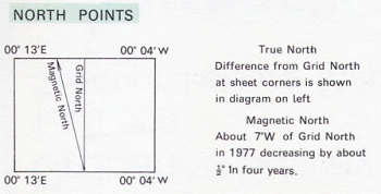
The magnetic variation throughout Great Britain currently ranges from 2º to 6º. The level of variation changes with location as well as changing annually. This information is given on an Ordnance Survey map (see example below). It is therefore important to make sure that maps stay up to date. The diagram above shows a magnetic variation value of about 7°W for an Ordnance Survey map of Purbeck, UK in 1977. The value in 2013 is a little over 2° W.
Message to World Magnetic Model (WMM) Users NOAA/NCEI – March 21, 2018
The WMM Gridded Variation (GV) error has recently exceeded the performance specification in the Arctic region. Other geographic areas and other model parameters are not affected. The increased GV error may adversely affect compass navigation in those areas. This performance degradation is caused by fast changing core flows in the North polar region of the Earth’s outer core.
The magnetic variation throughout Great Britain currently ranges from 2º to 6º. The level of variation changes with location as well as changing annually. This information is given on an Ordnance Survey map (see example below). It is therefore important to make sure that maps stay up to date.
 The diagram above shows a magnetic variation value of about 7°W for an Ordnance Survey map of Purbeck, UK in 1977. The value in 2013 is a little over 2° W.
Message to World Magnetic Model (WMM) Users NOAA/NCEI – March 21, 2018
The WMM Gridded Variation (GV) error has recently exceeded the performance specification in the Arctic region. Other geographic areas and other model parameters are not affected. The increased GV error may adversely affect compass navigation in those areas. This performance degradation is caused by fast changing core flows in the North polar region of the Earth’s outer core.
Copyright © 2019 - 2026 All Rights Reserved
Barcelona Field Studies Centre S.L.