Help topics
- Purpose of the site
- Compass features
- Compass menu
- Compass or GPS - advantages and disadvantages
- Compass Test
- Draw a single or multi-legged route
- Extending the compass direction of travel arrow
- False readings when using a compass
- Fine Tuning the OpenStreetMap Compass
- Getting started with OpenStreetMap Compass
- GPS or Compass - pros and cons for navigation
- Grid references test
- How to use a compass
- Import OpenStreetMap routes
- Key
- Latitude and longitude positions: degrees, minutes and seconds
- Magnetic declination or variation
- Magnetic declination or variation adjustment
- Magnetic declination or variation calculation
- Map projections
- Map reading
- Map reading skills test
- Menu
- Moving the OpenStreetMap Compass
- My OpenStreetMap Compass Map Routes
- Negative magnetic declination or variation
- New Features
- North: different types
- North on OpenStreetMap
- Ordnance Survey maps integration
- OpenStreetMap Key
- Panning and Zooming with OpenStreetMap
- Positive magnetic declination or variation
- Print Map Function
- Projection of OpenStreetMap
- Route drawing
- Route Information Display
- Safety
- Save and Store OpenStreetMap Compass Map Routes
- Single leg or multi-legged routes?
- Test your compass reading skills
- Tips
- Types of bearings
- Updates
- User Guide
- Watch as Compass
- What is a compass?
- What type of compass is used on the site?
- Zooming with OpenStreetMap
How can we calculate magnetic declination or variation at any given place?

One way would be to use magnetic declination or variation values provided on maps. Unfortunately, declination values are constantly changing.

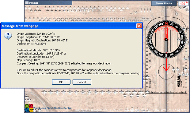
Our https://osmcompass.com website computes declination for any place on Earth using an algorithm that implements the updated World Magnetic Model. An example for the Aircraft Graveyard in Tuscon is shown below where the declination is computed as 10º 28' 48" E (10.48º).
Users of magnetic-field models and charts must be aware of their limitations. The Earth's magnetic field is extremely complicated, in both space and time, and magnetic-field models are, by practical necessity, something of an approximation of the actual magnetic field.
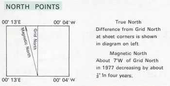
When printed maps were the only way of getting this information, the declination values were somewhat out of date by the time the maps got to the general public. The diagram to the right shows a negative magnetic variation value of about 7°W for an Ordnance Survey map of Purbeck, UK in 1977. The value in 2011 was a little over 2° W, and February 2019, 0.71° W ± 0.36° changing by 0.19° E per year.
Another way would be to perform a prediction. This Magnetic Field Calculator operated by the National Oceanic and Atmospheric Administration (NOAA) offers an estimated value for declination. The model reflects a highly predictable rate of change, and will usually be more accurate than a map, and almost never less accurate. A Mobile Magnetic Field Calculator is also available.
Another way would be to perform a prediction. This Magnetic Field Calculator operated by the National Oceanic and Atmospheric Administration (NOAA) offers an estimated value for declination. The model reflects a highly predictable rate of change, and will usually be more accurate than a map, and almost never less accurate. A Mobile Magnetic Field Calculator is also available.

Our https://osmcompass.com website computes declination for any place on Earth using an algorithm that implements the updated World Magnetic Model. An example for the Aircraft Graveyard in Tuscon is shown below where the declination is computed as 10º 28' 48" E (10.48º).

Tucson Aircraft Graveyard: positive magnetic variation or declination of approximately 10.5°
Users of magnetic-field models and charts must be aware of their limitations. The Earth's magnetic field is extremely complicated, in both space and time, and magnetic-field models are, by practical necessity, something of an approximation of the actual magnetic field.
Copyright © 2019 - 2026 All Rights Reserved
Barcelona Field Studies Centre S.L.